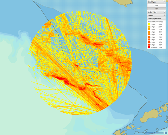
ABSI has helped deploy the first marine ‘geofence’ around the Pribilof Islands as a tool that can alert managers and communities when vessels greater than 300 tons (~60’ or more in length) cross into virtually-fenced areas (“geofences”) around sensitive habitats. Since July 2019, a network of concentric geofences around 14 northern fur seal haulouts on the Pribilof Islands. These preliminary results are being shared with the North Pacific Fisheries Management Council in January by our partners from the Aleut Community of St. Paul to demonstrate the amount of overlap with vessel traffic (Figure 1). We have also worked with the Alaska Department of Fish and Game, NOAA, and the USFWS to establish a Togiak Bay geofence Network and another dozen geofences have been placed around walrus haulouts in the Bering and southern Chukchi seas. In July of 2020, another five fences were established around Steller Sea Lion haulouts along the Aleutians and Alaska Peninsula. We also worked with the Native Village of Diomede to establish 2 geofences that allow them to monitor vessel traffic in the vicinity of their island community in the Bering Strait. This new domain awareness tool is currently available to agencies and tribes and with funding from the Arctic Domain Awareness Center and the Wildlife Conservation Society was developed in partnership over 18 months with input from dozens of managers, scientists as well as leaders from communities and industry.